

Day 1: Ronny Creek to Waterfall Valley + Barn Bluff Summit
We left Launceston at 6.30am and headed straight to Sheffield for a ham, cheese croissant and coffee at Bossimis Café and arrived at Ronny Creek by 9am.
After some faffing about with our bags we were on the trail by 9.30am.
The walk begins on boardwalk through buttongrass plains which is home to many wombats. Depending on the time of day you’ll see upwards of 10+ wombats between the starting point and the bridge (about 100m).
Once we’re out of wombat land the track begins to ascend, gently at first but as we hit our first dose of rainforest for the week the climb becomes steeper. It’s here that the track comes right past Crater Falls – we fill up water here as it’s much nicer than town water ;-)


Another 10-15minutes up from the falls the track opens up to Crater Lake, with the picturesque boat shed lining it’s shores.
We know there’s a lot of climbing to be done today so don’t hang around too long and continue onwards and upwards.
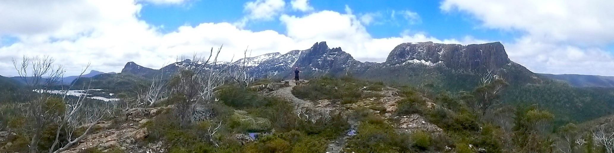
Another 15-20minutes after the lake we begin the climb up the infamous Marion’s Lookout. This is a rocky section that has a chain to help you pull yourself up. It is steep but this particular section is actually quite short. Once at the top of the chained section, we continue on for another 15minutes to reach the top of Marion’s Lookout.
We were so lucky to have such a sunny and still day and were rewarded with stunning views of Cradle Mountain – many miss out on this view!
After catching our breath and snapping a few shots we move on, knowing that the worst is now behind us (except for two of us who are hoping to summit Barn Bluff). From Marion’s lookout it’s a lovely walk over to Kitchen Hut, we’ll call it ‘Tassie flat’. There was a bit of snow about which was fun to play in, this section does tend to get the most snow and hold onto it for the longest too.


It’s about 45minutes from Marion’s Lookout to Kitchen Hut and, when we arrive we have a rest and have some lunch – It was roughly 12pm by the time we made it to the hut.
This is the point where hikers can leave their packs behind and climb Cradle Mountain. We’d all climbed Cradle plenty of times in the past and had our eyes set on Barn Bluff for today so pushed on.
From the hut, the track takes us around the base of Cradle Mountain, with Fury Gorge out to West – the views are stunning!
We pass by the emergency shelter which has been extremely helpful for those coming through this section in blizzard conditions and roughly an hour after departing Kitchen Hut we arrive at the track junction for Barn Bluff. It is from here that you can either climb the mountain or make your way down to Waterfall Valley Hut.
We have a quick snack, reshuffle our bags around and get ready to climb the mountain! We have packed in our day bags our rain jackets, gloves, micro spikes, PLB, water and snacks for the hike.
The approach to Barn Bluff is quite long, which is nice to stretch out the legs after carrying the heavy pack all the way here. We were joined by 2 wedge tailed eagles part way into the walk which was incredible. It took us about 45minutes to reach what I call the true beginning of the climb – where we hit the scree slope! From here, we pick our way up the rocks, following cairns and markers as we go. Part way up we have to stop to put on our microspikes as we have hit the snow line and the extra grip they provide is necessary.


All mountains in Tassie have at least 1 false summit, and Barn Bluff is no different. Within 20minutes we pop up onto the top ridge of Barn Bluff look to our right to see the true summit and clamber our way over.
It took us 1.5hours from leaving the track junction to reach the summit and 45minutes from the scree slope.
It was remarkably still and warm on top of Barn Bluff, which is extremely rare and lucky! After snapping a few shots and having a celebratory swig from our hipflask we begin the journey back down.
About 1hour 15minutes later we are back at our packs and ready to hike down to Waterfall Valley. The track follows the edge of the plateau before a steep climb down to the hut begins. This section is stunning, lined with Pandanus, scorparia and celery top pine.
We were in at Waterfall, setting up our tent about an hour after leaving the junction, roughly 5pm.
Total distance: 17.7km
Total time: 7.5 hours
Day 2: Waterfall Valley to New Pelion Hut
Today we decided to skip Windermere Hut and continue on to Pelion. There were a few reasons for this, mainly that we wanted to get to Pine Valley later in the trip and have 2 nights there but also because from Waterfall to Windermere it is a short day.
We’d all been to visit Lake Will many times in the past so decided to skip that side trip, had we been staying at Windermere instead of doing the double day I would have gone down to the lake. We had another sunny clear day and the reflection of Barn Bluff in the lake is amazing.
We had a light dusting of snow overnight which was magical to wake up to and we thoroughly enjoyed walking through it for the first part of our day.


We hit the track at about 9.15am, planned on 8am but had a lazy morning.
The first part of the walk takes us around the rim of Waterfall Valley Cirque – the views out to the East are stunning. We start to recognise mountains in the distance – Pelion West, Oakleigh and one that we all recognise but can’t put our finger on. Thankyou Nick for arriving in time to help us solve that mystery… it was High Dome and the Amphitheatre!
As we get closer to Windermere the lake comes into view, this section of trail is really stunning. I love the open vegetation of Alpine environments.
We arrive at Windermere by 11am, have a quick snack and continue on. We are mindful that today is going to be a big day on the track (and we had a delayed start) so try not to dilly dally too much.
The first section between Windermere and Pelion changes between the Alpine and mixed forest.. ducking in and out of buttongrass plains with little pockets of forest in between. About an hour in we arrive at the Forth Valley Lookout, time for another snack as we are aiming to have lunch a bit closer to the finish line! From the lookout we start entering into some magical rainforest sections along Pine Forest Moor – there are some truly spectacular Pencil Pines and King Billy Pines through here.
We arrive at Pelion Creek at about 1.30pm and stop here for some lunch and to top up water. From here the track descends down to Frog Flats. Occasional glimpses of Mount Oakleigh are seen out to the east as the vegetation thins but mostly this section is the iconic tree-root and mud that Tassie is known for. Just past frog flats we arrive at the Forth River, this is the end of the downhill and the lowest section of the entire trail at 730m. This is also the start of the climb up to Pelion. We stop for a snack and to take off a layer of clothing in preparation for the climb. It’s not extremely steep, we did worse yesterday but, after a long day on the trail we are all pretty fatigued! Slowly but surely, we make our way up to New Pelion Hut. We pass the turn of for Old Pelion Hut along the way, and arrive in time to set up our tents and make our way down to the hut before sunset. We arrived at about 5pm.
Total Distance: 24.6km
Total Time: 8 hours


Day 3: New Pelion Hut to Kia Ora
Having just smashed out 2 quite big days on the trail, we are keen for chill day! We make no plans to depart at a certain time and just enjoy getting through the morning routine in our own time…. Watching the sunrise on Mount Oakleigh is always a treat and we were lucky enough to still have views of Barn Bluff and Cradle which were also glowing in the morning sun!
A delicious breaky down on the heli-pad, two coffees and a slow but steady camp pack down had us departing at about 10.30am.


Whilst today is a comparatively shorter day than our previous two days, it is still a challenging one! The climb up to Pelion Gap is no mean feat with 300m of elevation to gain. We plod along the trail at a much easier pace, with no strong intent… just enjoying the walk and the lazy morning that we’ve had. We climb up over more tree-roots and through mud in the rainforest until the canopy opens up and we pop up onto Pelion Gap – and what a day it is to be up here! Conditions were perfect, the sun was out and there was hardly a breath of wind.
Many other hikers had dropped their packs to take the side trip up Mount Ossa or Pelion East. We sat, enjoyed the sun while we could and had some lunch.. pondering our options. Still feeling fatigued from the previous two days and craving a nice early arrival into camp (which is definitely something I really enjoy when hiking) we decided to skip the mountains today and mosey on down to Kia Ora. I definitely wish that I had the motivation and desire to climb a mountain that day as the conditions were perfect, but sometimes…. You just gotta go with what you really feel. The mountains will always be there :-)


We made our way down the other side of the gap, back down the 300m we had just climbed up to arrive at Kia Ora at about 2pm. We got ourselves set up on a tent platform and enjoyed the afternoon on the picnic table out the back of the hut with views of Cathedral Mountain, Falling Mountain and Mt Massif.
Total distance: 8.6km
Total time: 3.5 hours

Day 4: Kia Ora to Pine Valley
Another double day for us on the trail, we were still aiming for our 2 nights at Pine Valley! We left Kia Ora at about 8.45am and began the gentle climb up to Du Cane Hut. Today was a day full of stunning rainforest and of course, plenty of tree roots. There was mud, but I’ve definitely experienced much worse on this trail. A bonus for us was that in the morning the mud was usually frozen, which is just a treat to walk through!
We had a quick stop at the hut, it’s always nice to poke our heads in and have a look, before continuing on through the rainforest toward the waterfall side trips. Having been down the waterfalls many times in the past and with our plans to go through to Pine Valley we decided not to see them this time around. I can imagine they would have been extremely impressive this time of year with the snow and rain that fell the week prior to our hike.


From the Hartnett Falls turn off the track climbs steadily to the top of Du Cane Gap. I love this section of the trail, on a day like we had with sunshine and no wind we could really enjoy the views on top as we loped along the track.
Once we reached the official peak of the gap we stopped for a quick snack before making our way down to Bert Nichols Hut.
This section of downhill is quite long and tree-rooty. It winds its way down through rainforest and into more of a mixed forest where giant gum trees remain with huge burls coming out of their ancient trunks and remnants of the old logging days appear.
We arrived at Bert Nichols by about 12.30pm, hung up our wet tents in the sunshine and enjoyed lunch on the little outdoor deck looking out toward Mt Massif.

We departed the hut knowing that the next section of trail is quite gentle and enjoyed picking up our pace on the flatter sections. The forest through here turns to the classic dry sclerophyll bush, with hakeas and banksias dominating. Perhaps because of the different vegetation we noticed the bird song was much more predominant through this area. Roughly an hour and a half later we arrived at the track junction for Pine Valley. Stopped for a snack and then began our walk into Pine Valley.
Despite the fact that today had been a big day again, the walk into Pine Valley was so enjoyable. There are many creeks to cross, big suspension bridges and, as we got closer and closer to the hut we again entered into incredible rainforest, full of celery top pine and Cephissus Creek the most picturesque creek that looks like the perfect home for a platypus or two.
It took us an hour and half to reach Pine Valley from the junction, arrived at roughly 4pm. We set up our tents and made our way to the hut to get cosy by the coal fire, which is a massive bonus at this hut! It’s definitely not an easy task to get the coal fire going, those who had arrived before us had been trying for a good hour before we got there. They passed the baton on to us and it took what felt like another hour before we were able to sit back, relax and enjoy the warmth – these coal heaters are 100 x more effective than the gas heaters in the other huts (which we didn’t even bother with).
Total distance: 19.3km
Total time: 7 hours


Day 5: Rest day/Labyrinth
The start to today was very similar to our morning at Pelion. No schedule, to timings, just taking it easy and enjoying the morning. We treated ourselves to a nice hot breaky, which has become a hiking tradition for us, spent a long time getting that coal fire going again and finally geared up for our walk up to the Labyrinth at about 11am.
Today was our first grey day! We knew that was going to be the case so hadn’t set our goals on climbing the Acropolis.
The walk up to the Labyrinth is steep! We all hope to one day hike the Du Cane traverse so in the back of our minds we were imagining coming up here with our full hiking kit – yikes!
As today was a restful day, I didn’t pay attention to time and just enjoyed the walk. We popped up on top and followed the track around the Western edge of the Parthenon, making our way toward the lookout North of Lake Ophion.
The wind was epic and cold so when we got to the section of track that descends down to Lake Ophion we decided to turn back, there were some big nasty clouds rolling in at this stage. We sheltered behind some rocks for a quick snack and slowly made our way back down to the hut, arriving at roughly 2pm.
Total distance: maybe 4km
Total time: 3ish hours
Day 6: Pine Valley to Echo Point
By this stage of the game I’m really losing track of time, which is great! I think we left Pine Valley at 9.30am though. The walk back to the junction was just as enjoyable, if not more enjoyable, than the way in (as we had fresh feet this time!).
We pick up the Overland Track again at the junction and head South towards Narcissus Hut. This section is definitely the easiest part of the whole trail, which is lovely as it allows us to look up and take in the scenery a bit more as we walk. Not far from the hut we cross the Narcissus River on a swing bridge and arrive shortly after that to have some lunch and rest before continuing on.
It took us an hour to get from the track junction to Narcissus.
Having walked the Overland Track many times in the past but only the section between Narcissus and Cynthia Bay once… we were all pretty excited to experience this section and it did not disappoint. Easily the most beautiful section of rainforest walking on the whole trail, the trees are HUGE, there’s fungus and vibrant green lichen.. it feels ancient in here.
We all thoroughly enjoyed this section of track and arrived at Echo Point 2 hours after departing Narcissus thoroughly in love.


The hut at Echo Point is a very small, old hut, renowned for having rats that will eat your food, your gear.. even nibble on your fingers at night! It is also quaint, rustic and very cosy… we loved it. There are rat proof boxes to store your gear and food so there’s really no danger of having a rat attack at all. The campsites are gorgeous, the lake was high for us so we couldn’t camp on the beach but were happy in our little forest nook.
We arrived at the hut at about 2.30 and enjoyed the afternoon lighting the coal fire, taking in the views from the jetty and watching the sun set on our last day on the trail.
Total distance: 15.2km
Total time: 5 hours


Day 7: Our last day! Echo Point to Cynthia Bay
So today we had a timeframe…. We needed to be out by 12pm in time to go grab a burger from the Hungry Wombat before heading home (priorities right!)
Our earliest start to the day had us on the trail at 7.45am, right back into that stunning rainforest that we enjoyed so thoroughly the day prior. The bird song was incredible this morning, with yellow-tailed black cockatoos making a racket any time we came close.
After roughly 2 hours of rainforest bliss the vegetation changes once more back to a Eucalypt forest, the canopy opens up and we had views across Lake St Clair to Pumphouse Point.
About 30minutes later we reach Watersmeet, where the Cuvier and Hugel rivers meet before emptying into Lake St Clair. We cross the bridge and bid farewell to the trail before walking down the bitumen road to the Lake St Clair Lodge.
We arrived around 11am, with time to have a shower, change into fresh clothes and make our way to the Hungry Wombat for that burger that had been on our minds all morning.
Total distance: 11km
Total time: 3 hours
7 Day Combined total distance: 100.4kms
